


Binic

MoiClaude
User
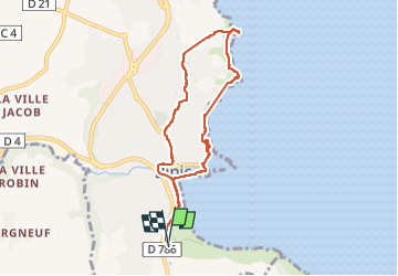

Length
7.2 km

Max alt
75 m

Uphill gradient
151 m
Km-Effort
9.2 km

Min alt
0 m

Downhill gradient
146 m
Boucle
Yes
Creation date :
2022-07-10 13:29:53.555
Updated on :
2022-07-10 16:20:22.336
2h24
Difficulty : Medium

FREE GPS app for hiking
 SityTrail
IGN / Geographical institutes
SityTrail Plus
The world is yours!
About
Trail Walking of 7.2 km to be discovered at Brittany, Côtes-d'Armor, Binic-Étables-sur-Mer. This trail is proposed by MoiClaude.
Description
Super
Positioning
Country:
France
Region :
Brittany
Department/Province :
Côtes-d'Armor
Municipality :
Binic-Étables-sur-Mer
Location:
Binic
Start:(Dec)
Start:(UTM)
512865 ; 5382269 (30U) N.
Comments