


bosson

noelphil
User

Length
7.3 km

Max alt
1678 m

Uphill gradient
313 m
Km-Effort
12.2 km

Min alt
1250 m

Downhill gradient
530 m
Boucle
No
Creation date :
2022-07-03 12:50:59.501
Updated on :
2022-07-10 20:00:32.748
3h03
Difficulty : Difficult

FREE GPS app for hiking
 SityTrail
IGN / Geographical institutes
SityTrail Plus
The world is yours!
About
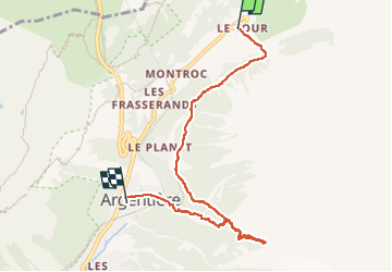
Trail Walking of 7.3 km to be discovered at Auvergne-Rhône-Alpes, Upper Savoy, Chamonix-Mont-Blanc. This trail is proposed by noelphil.
Description
glacier
Positioning
Country:
France
Region :
Auvergne-Rhône-Alpes
Department/Province :
Upper Savoy
Municipality :
Chamonix-Mont-Blanc
Location:
Unknown
Start:(Dec)
Start:(UTM)
340904 ; 5096397 (32T) N.
Comments