


2022-07-10_22h17m25_lKBJs9kHGuk

Gegetop
User
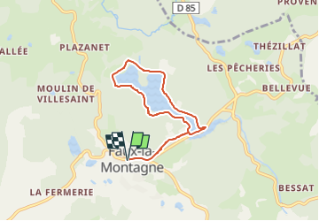

Length
6.4 km

Max alt
735 m

Uphill gradient
104 m
Km-Effort
7.8 km

Min alt
702 m

Downhill gradient
104 m
Boucle
Yes
Creation date :
2022-07-10 20:17:25.331
Updated on :
2022-07-10 20:25:39.164
1h46
Difficulty : Medium

FREE GPS app for hiking
 SityTrail
IGN / Geographical institutes
SityTrail Plus
The world is yours!
About
Trail Walking of 6.4 km to be discovered at New Aquitaine, Creuse, Faux-la-Montagne. This trail is proposed by Gegetop.
Positioning
Country:
France
Region :
New Aquitaine
Department/Province :
Creuse
Municipality :
Faux-la-Montagne
Location:
Unknown
Start:(Dec)
Start:(UTM)
417022 ; 5066843 (31T) N.
Comments