


la forêt de Thelle

serge.guerroult
User
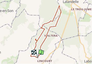

Length
14.7 km

Max alt
229 m

Uphill gradient
264 m
Km-Effort
18.2 km

Min alt
104 m

Downhill gradient
264 m
Boucle
Yes
Creation date :
2022-07-12 06:59:32.406
Updated on :
2022-07-12 10:45:52.965
2h27
Difficulty : Difficult

FREE GPS app for hiking
 SityTrail
IGN / Geographical institutes
SityTrail Plus
The world is yours!
About
Trail Walking of 14.7 km to be discovered at Hauts-de-France, Oise, Flavacourt. This trail is proposed by serge.guerroult.
Description
du petit lincourt au coin de la queue
Positioning
Country:
France
Region :
Hauts-de-France
Department/Province :
Oise
Municipality :
Flavacourt
Location:
Unknown
Start:(Dec)
Start:(UTM)
415090 ; 5467069 (31U) N.
Comments