


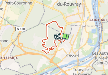
20220712-Oissel

doudet
User

Length
12.7 km

Max alt
94 m

Uphill gradient
136 m
Km-Effort
14.5 km

Min alt
41 m

Downhill gradient
137 m
Boucle
Yes
Creation date :
2022-07-12 11:46:17.937
Updated on :
2022-07-13 06:15:27.241
3h33
Difficulty : Easy

FREE GPS app for hiking
 SityTrail
IGN / Geographical institutes
SityTrail Plus
The world is yours!
About
Trail Walking of 12.7 km to be discovered at Normandy, Seine-Maritime, Oissel. This trail is proposed by doudet.
Description
Boucle A-R au départ de l'Hopital de Oissel
Belle Rando en cas de grosses chaleurs
Positioning
Country:
France
Region :
Normandy
Department/Province :
Seine-Maritime
Municipality :
Oissel
Location:
Unknown
Start:(Dec)
Start:(UTM)
360792 ; 5468297 (31U) N.
Comments