


Gare de St Nom - Boucle nocturne Gr ~2h 8,5km

sebastienu
User
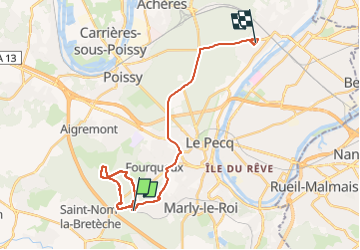

Length
24 km

Max alt
192 m

Uphill gradient
296 m
Km-Effort
28 km

Min alt
45 m

Downhill gradient
393 m
Boucle
No
Creation date :
2022-07-12 19:12:44.216
Updated on :
2022-07-13 07:30:51.576
12h14
Difficulty : Easy

FREE GPS app for hiking
 SityTrail
IGN / Geographical institutes
SityTrail Plus
The world is yours!
About
Trail Walking of 24 km to be discovered at Ile-de-France, Yvelines, L'Étang-la-Ville. This trail is proposed by sebastienu.
Description
Départ gare SNCF de St Nom la Bretèche, boucle nocturne sur GR avec crochet sur Joyenval et passage par la croix St Michel
~2h 8,5km
Positioning
Country:
France
Region :
Ile-de-France
Department/Province :
Yvelines
Municipality :
L'Étang-la-Ville
Location:
Unknown
Start:(Dec)
Start:(UTM)
430358 ; 5413069 (31U) N.
Comments
La boucle de termine au retour sur la gare de St Nom, au point de départ.