


la Canourgue la roquette

Dupuybadonniere
User
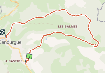

Length
12 km

Max alt
921 m

Uphill gradient
352 m
Km-Effort
16.9 km

Min alt
561 m

Downhill gradient
387 m
Boucle
No
Creation date :
2022-07-14 07:06:19.955
Updated on :
2022-07-14 10:57:00.309
3h00
Difficulty : Difficult

FREE GPS app for hiking
 SityTrail
IGN / Geographical institutes
SityTrail Plus
The world is yours!
About
Trail Walking of 12 km to be discovered at Occitania, Lozère, La Canourgue. This trail is proposed by Dupuybadonniere.
Positioning
Country:
France
Region :
Occitania
Department/Province :
Lozère
Municipality :
La Canourgue
Location:
La Canourgue
Start:(Dec)
Start:(UTM)
517974 ; 4918883 (31T) N.
Comments