


Château et chapelle

inesmyt
User
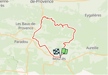

Length
30 km

Max alt
320 m

Uphill gradient
508 m
Km-Effort
37 km

Min alt
11 m

Downhill gradient
508 m
Boucle
Yes
Creation date :
2022-07-15 06:30:08.0
Updated on :
2022-07-15 06:30:09.704
2h31
Difficulty : Difficult

FREE GPS app for hiking
 SityTrail
IGN / Geographical institutes
SityTrail Plus
The world is yours!
About
Trail Mountain bike of 30 km to be discovered at Provence-Alpes-Côte d'Azur, Bouches-du-Rhône. This trail is proposed by inesmyt.
Positioning
Country:
France
Region :
Provence-Alpes-Côte d'Azur
Department/Province :
Bouches-du-Rhône
Municipality :
Unknown
Location:
Unknown
Start:(Dec)
Start:(UTM)
651103 ; 4839140 (31T) N.
Comments