


Corbel-2022-G1

Valmeinier
User
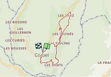

Length
7.4 km

Max alt
1004 m

Uphill gradient
380 m
Km-Effort
12.5 km

Min alt
664 m

Downhill gradient
380 m
Boucle
Yes
Creation date :
2022-07-15 13:38:11.027
Updated on :
2022-07-15 13:38:11.027
2h50
Difficulty : Difficult

FREE GPS app for hiking
 SityTrail
IGN / Geographical institutes
SityTrail Plus
The world is yours!
About
Trail Walking of 7.4 km to be discovered at Auvergne-Rhône-Alpes, Savoy, Corbel. This trail is proposed by Valmeinier.
Positioning
Country:
France
Region :
Auvergne-Rhône-Alpes
Department/Province :
Savoy
Municipality :
Corbel
Location:
Unknown
Start:(Dec)
Start:(UTM)
721012 ; 5034616 (31T) N.
Comments