La Plate-G2

Valmeinier
User
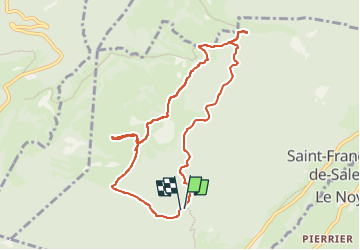

Length
8.9 km

Max alt
1381 m

Uphill gradient
237 m
Km-Effort
12.1 km

Min alt
1244 m

Downhill gradient
240 m
Boucle
Yes
Creation date :
2022-07-15 14:10:12.138
Updated on :
2022-07-19 06:27:21.544
2h45
Difficulty : Difficult

FREE GPS app for hiking
 SityTrail
IGN / Geographical institutes
SityTrail Plus
The world is yours!
About
Trail Walking of 8.9 km to be discovered at Auvergne-Rhône-Alpes, Savoy, Saint-François-de-Sales. This trail is proposed by Valmeinier.
Positioning
Country:
France
Region :
Auvergne-Rhône-Alpes
Department/Province :
Savoy
Municipality :
Saint-François-de-Sales
Location:
Unknown
Start:(Dec)
Start:(UTM)
268911 ; 5062548 (32T) N.
Comments