


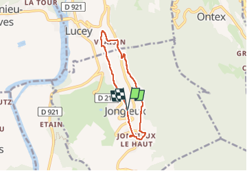
Jongieux-2022-G2

Valmeinier
User

Length
5.7 km

Max alt
447 m

Uphill gradient
199 m
Km-Effort
8.4 km

Min alt
278 m

Downhill gradient
195 m
Boucle
Yes
Creation date :
2022-07-16 16:15:42.945
Updated on :
2022-07-16 16:15:42.945
1h54
Difficulty : Medium

FREE GPS app for hiking
 SityTrail
IGN / Geographical institutes
SityTrail Plus
The world is yours!
About
Trail Walking of 5.7 km to be discovered at Auvergne-Rhône-Alpes, Savoy, Jongieux. This trail is proposed by Valmeinier.
Positioning
Country:
France
Region :
Auvergne-Rhône-Alpes
Department/Province :
Savoy
Municipality :
Jongieux
Location:
Unknown
Start:(Dec)
Start:(UTM)
717813 ; 5068728 (31T) N.
Comments