


sentier du suquets

gdela
User
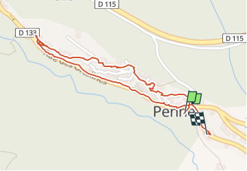

Length
1.2 km

Max alt
173 m

Uphill gradient
25 m
Km-Effort
1.5 km

Min alt
143 m

Downhill gradient
21 m
Boucle
Yes
Creation date :
2022-07-17 07:28:24.012
Updated on :
2022-07-17 08:05:15.548
25m
Difficulty : Easy

FREE GPS app for hiking
 SityTrail
IGN / Geographical institutes
SityTrail Plus
The world is yours!
About
Trail Walking of 1.2 km to be discovered at Occitania, Tarn, Penne. This trail is proposed by gdela.
Positioning
Country:
France
Region :
Occitania
Department/Province :
Tarn
Municipality :
Penne
Location:
Unknown
Start:(Dec)
Start:(UTM)
398361 ; 4881169 (31T) N.
Comments