


AR péage pdd ceyssat

jean-charlesSIMAND
User
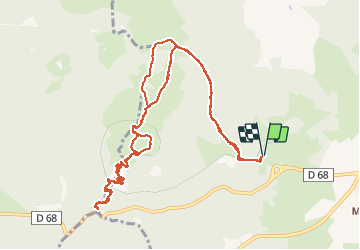

Length
13.3 km

Max alt
1458 m

Uphill gradient
898 m
Km-Effort
25 km

Min alt
908 m

Downhill gradient
898 m
Boucle
Yes
Creation date :
2014-12-10 00:00:00.0
Updated on :
2014-12-10 00:00:00.0
2h01
Difficulty : Unknown

FREE GPS app for hiking
 SityTrail
IGN / Geographical institutes
SityTrail Plus
The world is yours!
About
Trail Running of 13.3 km to be discovered at Auvergne-Rhône-Alpes, Puy-de-Dôme, Orcines. This trail is proposed by jean-charlesSIMAND.
Description
super
Positioning
Country:
France
Region :
Auvergne-Rhône-Alpes
Department/Province :
Puy-de-Dôme
Municipality :
Orcines
Location:
Unknown
Start:(Dec)
Start:(UTM)
498799 ; 5068569 (31T) N.
Comments