


Plateau (forêt uniquement)

topnature !
User

Length
7.3 km

Max alt
423 m

Uphill gradient
88 m
Km-Effort
8.5 km

Min alt
385 m

Downhill gradient
85 m
Boucle
Yes
Creation date :
2022-07-18 07:00:45.0
Updated on :
2022-07-18 09:19:49.79
2h17
Difficulty : Medium

FREE GPS app for hiking
 SityTrail
IGN / Geographical institutes
SityTrail Plus
The world is yours!
About
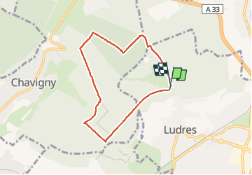
Trail Walking of 7.3 km to be discovered at Grand Est, Meurthe-et-Moselle, Ludres. This trail is proposed by topnature !.
Description
Ludres
Positioning
Country:
France
Region :
Grand Est
Department/Province :
Meurthe-et-Moselle
Municipality :
Ludres
Location:
Unknown
Start:(Dec)
Start:(UTM)
290616 ; 5390015 (32U) N.
Comments