


col du Sallestet

franquen
User
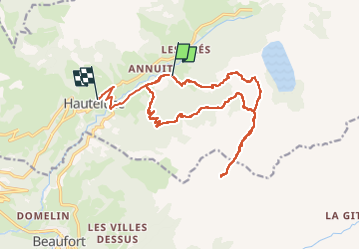

Length
19.5 km

Max alt
2117 m

Uphill gradient
1139 m
Km-Effort
35 km

Min alt
1032 m

Downhill gradient
1180 m
Boucle
No
Creation date :
2022-07-18 06:35:45.096
Updated on :
2022-07-18 14:43:44.286
8h02
Difficulty : Medium

FREE GPS app for hiking
 SityTrail
IGN / Geographical institutes
SityTrail Plus
The world is yours!
About
Trail Walking of 19.5 km to be discovered at Auvergne-Rhône-Alpes, Savoy, Hauteluce. This trail is proposed by franquen.
Positioning
Country:
France
Region :
Auvergne-Rhône-Alpes
Department/Province :
Savoy
Municipality :
Hauteluce
Location:
Unknown
Start:(Dec)
Start:(UTM)
314321 ; 5069828 (32T) N.
Comments