


Mionnay-43km-440m

ThierryJ01
User
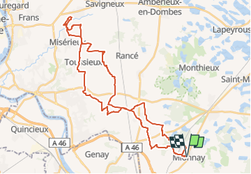

Length
43 km

Max alt
313 m

Uphill gradient
440 m
Km-Effort
49 km

Min alt
224 m

Downhill gradient
439 m
Boucle
Yes
Creation date :
2022-07-19 20:24:19.146
Updated on :
2022-07-19 20:27:16.065
3h23
Difficulty : Very difficult

FREE GPS app for hiking
 SityTrail
IGN / Geographical institutes
SityTrail Plus
The world is yours!
About
Trail Mountain bike of 43 km to be discovered at Auvergne-Rhône-Alpes, Ain, Mionnay. This trail is proposed by ThierryJ01.
Positioning
Country:
France
Region :
Auvergne-Rhône-Alpes
Department/Province :
Ain
Municipality :
Mionnay
Location:
Unknown
Start:(Dec)
Start:(UTM)
649728 ; 5084228 (31T) N.
Comments