


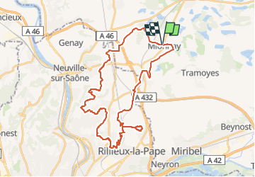
Mionnay-39km-513m

ThierryJ01
User

Length
39 km

Max alt
332 m

Uphill gradient
514 m
Km-Effort
46 km

Min alt
215 m

Downhill gradient
512 m
Boucle
Yes
Creation date :
2022-07-19 21:11:46.018
Updated on :
2022-07-19 21:13:27.52
3h10
Difficulty : Very difficult

FREE GPS app for hiking
 SityTrail
IGN / Geographical institutes
SityTrail Plus
The world is yours!
About
Trail Mountain bike of 39 km to be discovered at Auvergne-Rhône-Alpes, Ain, Mionnay. This trail is proposed by ThierryJ01.
Positioning
Country:
France
Region :
Auvergne-Rhône-Alpes
Department/Province :
Ain
Municipality :
Mionnay
Location:
Unknown
Start:(Dec)
Start:(UTM)
649723 ; 5084223 (31T) N.
Comments