


sagnes et goudoulet

raab
User
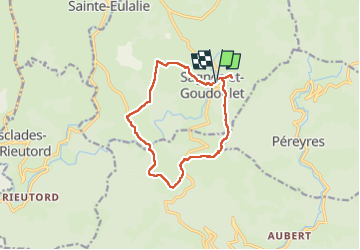

Length
12 km

Max alt
1293 m

Uphill gradient
250 m
Km-Effort
15.3 km

Min alt
1161 m

Downhill gradient
254 m
Boucle
Yes
Creation date :
2022-04-28 08:10:25.049
Updated on :
2022-07-20 20:49:33.114
4h44
Difficulty : Difficult

FREE GPS app for hiking
 SityTrail
IGN / Geographical institutes
SityTrail Plus
The world is yours!
About
Trail Walking of 12 km to be discovered at Auvergne-Rhône-Alpes, Ardèche. This trail is proposed by raab.
Positioning
Country:
France
Region :
Auvergne-Rhône-Alpes
Department/Province :
Ardèche
Municipality :
Unknown
Location:
Unknown
Start:(Dec)
Start:(UTM)
597013 ; 4960408 (31T) N.
Comments