


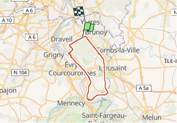
Rando vélo Rougeau Bord de seine

jeanmarcMasson
User GUIDE

Length
42 km

Max alt
99 m

Uphill gradient
338 m
Km-Effort
46 km

Min alt
29 m

Downhill gradient
386 m
Boucle
No
Creation date :
2022-05-01 09:11:32.187
Updated on :
2022-07-21 11:47:44.836
3h45
Difficulty : Very difficult

FREE GPS app for hiking
 SityTrail
IGN / Geographical institutes
SityTrail Plus
The world is yours!
About
Trail Bicycle tourism of 42 km to be discovered at Ile-de-France, Essonne, Montgeron. This trail is proposed by jeanmarcMasson.
Positioning
Country:
France
Region :
Ile-de-France
Department/Province :
Essonne
Municipality :
Montgeron
Location:
Unknown
Start:(Dec)
Start:(UTM)
460732 ; 5392758 (31U) N.
Comments