


col des mouilles-refuge jean collet

maupassant38
User
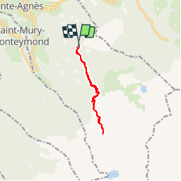

Length
11.2 km

Max alt
2038 m

Uphill gradient
816 m
Km-Effort
22 km

Min alt
1299 m

Downhill gradient
817 m
Boucle
Yes
Creation date :
2019-02-22 22:32:03.678
Updated on :
2019-02-22 22:32:03.743
4h34
Difficulty : Medium

FREE GPS app for hiking
 SityTrail
IGN / Geographical institutes
SityTrail Plus
The world is yours!
About
Trail Walking of 11.2 km to be discovered at Auvergne-Rhône-Alpes, Isère, Sainte-Agnès. This trail is proposed by maupassant38.
Description
col des mouilles-refuge jean collet
Photos

Positioning
Country:
France
Region :
Auvergne-Rhône-Alpes
Department/Province :
Isère
Municipality :
Sainte-Agnès
Location:
Unknown
Start:(Dec)
Start:(UTM)
732004 ; 5011901 (31T) N.
Comments