


La source Sté Anne

topnature !
User

Length
11.7 km

Max alt
349 m

Uphill gradient
217 m
Km-Effort
14.6 km

Min alt
215 m

Downhill gradient
231 m
Boucle
No
Creation date :
2022-07-22 11:55:34.0
Updated on :
2022-07-22 15:31:30.355
3h35
Difficulty : Medium

FREE GPS app for hiking
 SityTrail
IGN / Geographical institutes
SityTrail Plus
The world is yours!
About
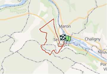
Trail Walking of 11.7 km to be discovered at Grand Est, Meurthe-et-Moselle, Sexey-aux-Forges. This trail is proposed by topnature !.
Description
Forêt
Positioning
Country:
France
Region :
Grand Est
Department/Province :
Meurthe-et-Moselle
Municipality :
Sexey-aux-Forges
Location:
Unknown
Start:(Dec)
Start:(UTM)
282363 ; 5389518 (32U) N.
Comments