


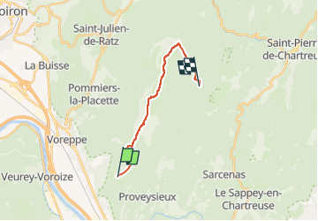
De Mont St Martin au col de la Charmette par le Col de la Sure

morganee
User

Length
14.9 km

Max alt
1756 m

Uphill gradient
1179 m
Km-Effort
29 km

Min alt
753 m

Downhill gradient
657 m
Boucle
No
Creation date :
2022-07-22 21:01:39.824
Updated on :
2022-07-22 21:01:41.5
6h34
Difficulty : Medium

FREE GPS app for hiking
 SityTrail
IGN / Geographical institutes
SityTrail Plus
The world is yours!
About
Trail Walking of 14.9 km to be discovered at Auvergne-Rhône-Alpes, Isère, Mont-Saint-Martin. This trail is proposed by morganee.
Positioning
Country:
France
Region :
Auvergne-Rhône-Alpes
Department/Province :
Isère
Municipality :
Mont-Saint-Martin
Location:
Unknown
Start:(Dec)
Start:(UTM)
709886 ; 5016697 (31T) N.
Comments