


Saint Jean d'Arves-Boucle du Chef-Lieu

nicolas54230
User
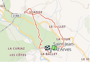

Length
4.6 km

Max alt
1613 m

Uphill gradient
236 m
Km-Effort
7.7 km

Min alt
1408 m

Downhill gradient
236 m
Boucle
Yes
Creation date :
2022-07-23 15:10:59.398
Updated on :
2022-07-23 15:11:53.664
1h45
Difficulty : Medium

FREE GPS app for hiking
 SityTrail
IGN / Geographical institutes
SityTrail Plus
The world is yours!
About
Trail Walking of 4.6 km to be discovered at Auvergne-Rhône-Alpes, Savoy, Saint-Jean-d'Arves. This trail is proposed by nicolas54230.
Positioning
Country:
France
Region :
Auvergne-Rhône-Alpes
Department/Province :
Savoy
Municipality :
Saint-Jean-d'Arves
Location:
Unknown
Start:(Dec)
Start:(UTM)
285493 ; 5009302 (32T) N.
Comments