


220724 - R.Princes - Denec.17

randodan
User
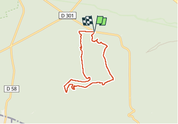

Length
6.8 km

Max alt
137 m

Uphill gradient
159 m
Km-Effort
9 km

Min alt
90 m

Downhill gradient
162 m
Boucle
Yes
Creation date :
2022-07-24 06:18:33.15
Updated on :
2022-07-27 10:41:30.41
8h41
Difficulty : Easy

FREE GPS app for hiking
 SityTrail
IGN / Geographical institutes
SityTrail Plus
The world is yours!
About
Trail Walking of 6.8 km to be discovered at Ile-de-France, Seine-et-Marne, Fontainebleau. This trail is proposed by randodan.
Positioning
Country:
France
Region :
Ile-de-France
Department/Province :
Seine-et-Marne
Municipality :
Fontainebleau
Location:
Unknown
Start:(Dec)
Start:(UTM)
481427 ; 5357765 (31U) N.
Comments