


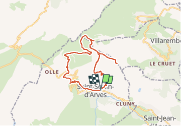
Saint Jean d'Arves-L'Ouillon

nicolas54230
User

Length
16 km

Max alt
2423 m

Uphill gradient
1099 m
Km-Effort
31 km

Min alt
1510 m

Downhill gradient
1098 m
Boucle
Yes
Creation date :
2022-07-28 06:20:01.704
Updated on :
2022-07-28 06:20:38.695
6h57
Difficulty : Very difficult

FREE GPS app for hiking
 SityTrail
IGN / Geographical institutes
SityTrail Plus
The world is yours!
About
Trail Walking of 16 km to be discovered at Auvergne-Rhône-Alpes, Savoy, Saint-Sorlin-d'Arves. This trail is proposed by nicolas54230.
Positioning
Country:
France
Region :
Auvergne-Rhône-Alpes
Department/Province :
Savoy
Municipality :
Saint-Sorlin-d'Arves
Location:
Unknown
Start:(Dec)
Start:(UTM)
282752 ; 5011275 (32T) N.
Comments