


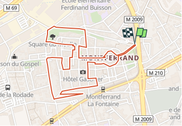
Circuit de Montferrand

jpcccb
User

Length
3.1 km

Max alt
357 m

Uphill gradient
46 m
Km-Effort
3.8 km

Min alt
337 m

Downhill gradient
47 m
Boucle
Yes
Creation date :
2022-07-28 13:50:44.724
Updated on :
2022-07-28 14:15:02.264
49m
Difficulty : Easy

FREE GPS app for hiking
 SityTrail
IGN / Geographical institutes
SityTrail Plus
The world is yours!
About
Trail Walking of 3.1 km to be discovered at Auvergne-Rhône-Alpes, Puy-de-Dôme, Clermont-Ferrand. This trail is proposed by jpcccb.
Positioning
Country:
France
Region :
Auvergne-Rhône-Alpes
Department/Province :
Puy-de-Dôme
Municipality :
Clermont-Ferrand
Location:
Unknown
Start:(Dec)
Start:(UTM)
509106 ; 5071190 (31T) N.
Comments