


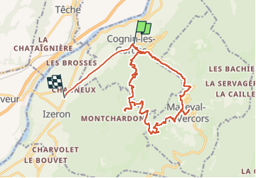
Cognin 2

raygautier
User

Length
21 km

Max alt
1160 m

Uphill gradient
1135 m
Km-Effort
36 km

Min alt
229 m

Downhill gradient
1183 m
Boucle
No
Creation date :
2022-07-28 06:20:54.0
Updated on :
2022-07-29 09:46:43.059
5h11
Difficulty : Very difficult
5h12
Difficulty : Difficult

FREE GPS app for hiking
 SityTrail
IGN / Geographical institutes
SityTrail Plus
The world is yours!
About
Trail Walking of 21 km to be discovered at Auvergne-Rhône-Alpes, Isère, Cognin-les-Gorges. This trail is proposed by raygautier.
Positioning
Country:
France
Region :
Auvergne-Rhône-Alpes
Department/Province :
Isère
Municipality :
Cognin-les-Gorges
Location:
Unknown
Start:(Dec)
Start:(UTM)
689566 ; 5004746 (31T) N.
Comments