


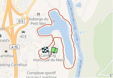
le grand Mas, camping Issoire

gdela
User

Length
2.5 km

Max alt
375 m

Uphill gradient
21 m
Km-Effort
2.8 km

Min alt
363 m

Downhill gradient
21 m
Boucle
Yes
Creation date :
2022-07-30 15:29:22.726
Updated on :
2022-07-30 16:11:38.146
41m
Difficulty : Easy

FREE GPS app for hiking
 SityTrail
IGN / Geographical institutes
SityTrail Plus
The world is yours!
About
Trail Walking of 2.5 km to be discovered at Auvergne-Rhône-Alpes, Puy-de-Dôme, Issoire. This trail is proposed by gdela.
Description
tour de l'étang
Positioning
Country:
France
Region :
Auvergne-Rhône-Alpes
Department/Province :
Puy-de-Dôme
Municipality :
Issoire
Location:
Unknown
Start:(Dec)
Start:(UTM)
521379 ; 5044016 (31T) N.
Comments