


Brié- Table d'orientation

crocau
User

Length
3.1 km

Max alt
558 m

Uphill gradient
91 m
Km-Effort
4.3 km

Min alt
473 m

Downhill gradient
90 m
Boucle
Yes
Creation date :
2022-07-30 17:47:34.763
Updated on :
2022-07-30 18:47:16.836
59m
Difficulty : Very easy

FREE GPS app for hiking
 SityTrail
IGN / Geographical institutes
SityTrail Plus
The world is yours!
About
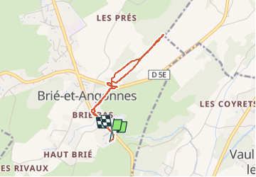
Trail Walking of 3.1 km to be discovered at Auvergne-Rhône-Alpes, Isère, Brié-et-Angonnes. This trail is proposed by crocau.
Description
Petite balade pour profiter des bois.
Photos


Positioning
Country:
France
Region :
Auvergne-Rhône-Alpes
Department/Province :
Isère
Municipality :
Brié-et-Angonnes
Location:
Unknown
Start:(Dec)
Start:(UTM)
719331 ; 4998831 (31T) N.
Comments