


Le Robuste

Alouest31
User
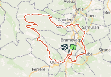

Length
26 km

Max alt
1526 m

Uphill gradient
1463 m
Km-Effort
46 km

Min alt
504 m

Downhill gradient
1490 m
Boucle
Yes
Creation date :
2022-07-30 08:25:15.0
Updated on :
2022-07-31 09:49:11.522
9h51
Difficulty : Very difficult

FREE GPS app for hiking
 SityTrail
IGN / Geographical institutes
SityTrail Plus
The world is yours!
About
Trail Walking of 26 km to be discovered at Occitania, Hautespyrenees, Mauléon-Barousse. This trail is proposed by Alouest31.
Positioning
Country:
France
Region :
Occitania
Department/Province :
Hautespyrenees
Municipality :
Mauléon-Barousse
Location:
Unknown
Start:(Dec)
Start:(UTM)
301830 ; 4759876 (31T) N.
Comments