


les châteaux du Mont saint odile

Titinechris
User
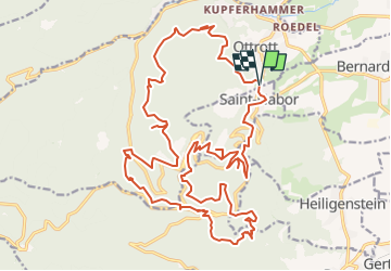

Length
29 km

Max alt
830 m

Uphill gradient
1324 m
Km-Effort
47 km

Min alt
313 m

Downhill gradient
1329 m
Boucle
Yes
Creation date :
2022-07-31 15:23:37.225
Updated on :
2022-07-31 15:26:46.453
0m
Difficulty : Medium

FREE GPS app for hiking
 SityTrail
IGN / Geographical institutes
SityTrail Plus
The world is yours!
About
Trail Trail of 29 km to be discovered at Grand Est, Bas-Rhin, Ottrott. This trail is proposed by Titinechris.
Positioning
Country:
France
Region :
Grand Est
Department/Province :
Bas-Rhin
Municipality :
Ottrott
Location:
Unknown
Start:(Dec)
Start:(UTM)
383517 ; 5367388 (32U) N.
Comments