


TOUR D’ARCES-BIVIER-EGLISE ST ISMIER-RIBOTIERRE

RD78-38
User
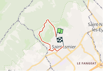

Length
4 km

Max alt
600 m

Uphill gradient
163 m
Km-Effort
6.4 km

Min alt
360 m

Downhill gradient
236 m
Boucle
No
Creation date :
2022-07-31 06:57:17.0
Updated on :
2022-08-01 17:08:10.174
34h02
Difficulty : Easy

FREE GPS app for hiking
 SityTrail
IGN / Geographical institutes
SityTrail Plus
The world is yours!
About
Trail Walking of 4 km to be discovered at Auvergne-Rhône-Alpes, Isère, Saint-Ismier. This trail is proposed by RD78-38.
Description
Tour facile en sous-bois
Positioning
Country:
France
Region :
Auvergne-Rhône-Alpes
Department/Province :
Isère
Municipality :
Saint-Ismier
Location:
Unknown
Start:(Dec)
Start:(UTM)
721406 ; 5014841 (31T) N.
Comments