


2022-08-02_17h10m48_Compostelle-Nord

dehemjacques
User
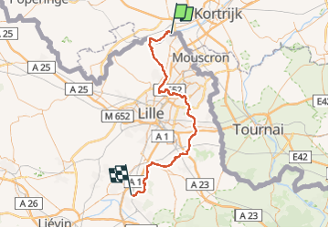

Length
67 km

Max alt
66 m

Uphill gradient
437 m
Km-Effort
73 km

Min alt
3 m

Downhill gradient
412 m
Boucle
No
Creation date :
2022-08-02 15:10:48.549
Updated on :
2022-08-02 15:11:01.24

FREE GPS app for hiking
 SityTrail
IGN / Geographical institutes
SityTrail Plus
The world is yours!
About
Trail of 67 km to be discovered at Flanders, West Flanders, Menin. This trail is proposed by dehemjacques.
Positioning
Country:
Belgium
Region :
Flanders
Department/Province :
West Flanders
Municipality :
Menin
Location:
Menin
Start:(Dec)
Start:(UTM)
508799 ; 5626588 (31U) N.
Comments