


verif

tomguerraz
User
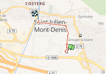

Length
949 m

Max alt
673 m

Uphill gradient
32 m
Km-Effort
1.3 km

Min alt
639 m

Downhill gradient
0 m
Boucle
No
Creation date :
2022-08-03 07:37:19.281
Updated on :
2022-08-03 09:30:05.76
1h03
Difficulty : Very easy

FREE GPS app for hiking
 SityTrail
IGN / Geographical institutes
SityTrail Plus
The world is yours!
About
Trail Trail of 949 m to be discovered at Auvergne-Rhône-Alpes, Savoy, Saint-Julien-Mont-Denis. This trail is proposed by tomguerraz.
Positioning
Country:
France
Region :
Auvergne-Rhône-Alpes
Department/Province :
Savoy
Municipality :
Saint-Julien-Mont-Denis
Location:
Unknown
Start:(Dec)
Start:(UTM)
296500 ; 5014325 (32T) N.
Comments