Trail On foot Saint-Paul - Cirkwi-Boucle_de_la_Manche - Photo

Cirkwi-Boucle_de_la_Manche

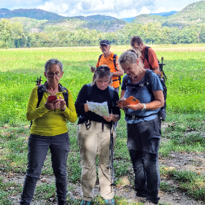
Une équipe à votre service garant de convivialité et bonne humeur

© OpenStreetMap contributors
Length
Length
9.1 km
Max alt
Max alt
553 m
Uphill gradient
Uphill gradient
263 m
Km-Effort
Km-Effort  
12.6 km
Min alt
Min alt
368 m
Downhill gradient
Downhill gradient
266 m
Boucle
Boucle
Yes
Creation date :
2022-08-03 12:51:34.614
Updated on :
2022-08-03 12:51:34.614

(0 Reviews)

On foot
On foot
2h51
Difficulty : Easy

Scan this QR Code to open this trail in the SityTrail application

FREE GPS app for hiking

Logo SityTrail SityTrail

IGN / Geographical institutes

Download SityTrail from the App Store Download SityTrail from Google Play

Logo SityTrail SityTrail Plus

The world is yours!

Download SityTrail from the App Store Download SityTrail from Google Play Download SityTrail on Huawei AppGallery

About

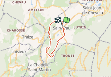
Trail On foot of 9.1 km to be discovered at Auvergne-Rhône-Alpes, Savoy, Saint-Paul. This trail is proposed by mini balades Adapar.

Description

Au pied du Mont du Chat, il vous est propose 4 boucles de promenade. La Boucle de la Manche est une variante de la Boucle des Pins. Depuis la Pierre des Borrels, vous prolongez votre parcours par le hameau les Vincents pour rejoindre celui du Petit Creux.

Elevation profile

Positioning

Country:
France
Region :
Auvergne-Rhône-Alpes
Department/Province :
Savoy
Municipality :
Saint-Paul
Location:
Unknown
Start:(Dec)
Start:(UTM)
716906 ; 5062005 (31T) N.


Close
My subscriptions