


hirsensteine sentier roches frankenthal hohneck kastelberg cascade charlemagne

Titinechris
User
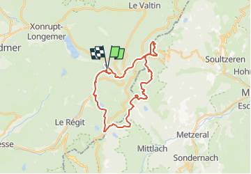

Length
28 km

Max alt
1355 m

Uphill gradient
1347 m
Km-Effort
46 km

Min alt
779 m

Downhill gradient
1346 m
Boucle
Yes
Creation date :
2022-08-04 10:24:32.066
Updated on :
2022-08-04 10:25:56.102
0m
Difficulty : Medium

FREE GPS app for hiking
 SityTrail
IGN / Geographical institutes
SityTrail Plus
The world is yours!
About
Trail Trail of 28 km to be discovered at Grand Est, Vosges, Xonrupt-Longemer. This trail is proposed by Titinechris.
Positioning
Country:
France
Region :
Grand Est
Department/Province :
Vosges
Municipality :
Xonrupt-Longemer
Location:
Unknown
Start:(Dec)
Start:(UTM)
350016 ; 5324529 (32U) N.
Comments