


St Goussaud

csy95
User
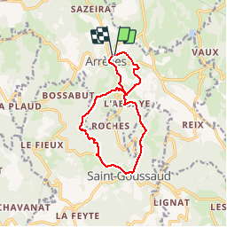

Length
12.4 km

Max alt
671 m

Uphill gradient
366 m
Km-Effort
17.3 km

Min alt
394 m

Downhill gradient
366 m
Boucle
Yes
Creation date :
2018-08-26 10:57:56.137
Updated on :
2018-08-26 10:57:56.181
3h07
Difficulty : Medium

FREE GPS app for hiking
 SityTrail
IGN / Geographical institutes
SityTrail Plus
The world is yours!
About
Trail Walking of 12.4 km to be discovered at New Aquitaine, Creuse, Arrènes. This trail is proposed by csy95.
Positioning
Country:
France
Region :
New Aquitaine
Department/Province :
Creuse
Municipality :
Arrènes
Location:
Unknown
Start:(Dec)
Start:(UTM)
389592 ; 5103112 (31T) N.
Comments