


Chambors les 4 communes en 15Km

serge.guerroult
User
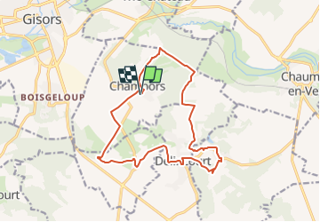

Length
14.8 km

Max alt
151 m

Uphill gradient
245 m
Km-Effort
18 km

Min alt
60 m

Downhill gradient
246 m
Boucle
Yes
Creation date :
2022-08-04 16:39:41.09
Updated on :
2022-08-04 17:35:02.224
5h05
Difficulty : Very difficult

FREE GPS app for hiking
 SityTrail
IGN / Geographical institutes
SityTrail Plus
The world is yours!
About
Trail Walking of 14.8 km to be discovered at Hauts-de-France, Oise, Chambors. This trail is proposed by serge.guerroult.
Positioning
Country:
France
Region :
Hauts-de-France
Department/Province :
Oise
Municipality :
Chambors
Location:
Unknown
Start:(Dec)
Start:(UTM)
413866 ; 5457008 (31U) N.
Comments