


trek albères j3 ullat laroque tracé carte

stef789
User GUIDE
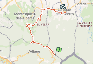

Length
14.3 km

Max alt
1020 m

Uphill gradient
307 m
Km-Effort
21 km

Min alt
90 m

Downhill gradient
1142 m
Boucle
No
Creation date :
2022-08-05 17:59:06.137
Updated on :
2022-08-05 18:00:31.385
4h49
Difficulty : Very difficult

FREE GPS app for hiking
 SityTrail
IGN / Geographical institutes
SityTrail Plus
The world is yours!
About
Trail Walking of 14.3 km to be discovered at Occitania, Pyrénées-Orientales, L'Albère. This trail is proposed by stef789.
Positioning
Country:
France
Region :
Occitania
Department/Province :
Pyrénées-Orientales
Municipality :
L'Albère
Location:
Unknown
Start:(Dec)
Start:(UTM)
493630 ; 4703007 (31T) N.
Comments