


Col de Susanfe et lac de Salanfe

aris
User
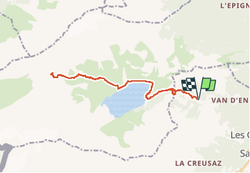

Length
18 km

Max alt
2523 m

Uphill gradient
1209 m
Km-Effort
34 km

Min alt
1387 m

Downhill gradient
1210 m
Boucle
Yes
Creation date :
2022-08-06 06:37:42.657
Updated on :
2022-08-21 06:06:31.157
7h17
Difficulty : Medium

FREE GPS app for hiking
 SityTrail
IGN / Geographical institutes
SityTrail Plus
The world is yours!
About
Trail Walking of 18 km to be discovered at Valais/Wallis, Saint-Maurice, Salvan. This trail is proposed by aris.
Positioning
Country:
Switzerland
Region :
Valais/Wallis
Department/Province :
Saint-Maurice
Municipality :
Salvan
Location:
Unknown
Start:(Dec)
Start:(UTM)
345012 ; 5111597 (32T) N.
Comments