


balade EFV

CDSM 55
User
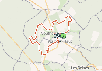

Length
16.3 km

Max alt
436 m

Uphill gradient
218 m
Km-Effort
19.2 km

Min alt
322 m

Downhill gradient
218 m
Boucle
Yes
Creation date :
2022-08-07 07:39:54.73
Updated on :
2022-08-07 09:45:03.158
1h40
Difficulty : Easy

FREE GPS app for hiking
 SityTrail
IGN / Geographical institutes
SityTrail Plus
The world is yours!
About
Trail Mountain bike of 16.3 km to be discovered at Grand Est, Meuse, Vouthon-Haut. This trail is proposed by CDSM 55.
Description
Sur une partie des chemins d'Isabelle avec Timaé et Elodie
Positioning
Country:
France
Region :
Grand Est
Department/Province :
Meuse
Municipality :
Vouthon-Haut
Location:
Unknown
Start:(Dec)
Start:(UTM)
693393 ; 5372508 (31U) N.
Comments