


anhee zdeps

BOSSARTHUBERT
User
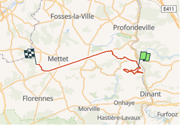

Length
36 km

Max alt
281 m

Uphill gradient
601 m
Km-Effort
43 km

Min alt
88 m

Downhill gradient
461 m
Boucle
No
Creation date :
2022-08-07 06:16:14.734
Updated on :
2022-08-07 11:02:52.272
4h44
Difficulty : Difficult

FREE GPS app for hiking
 SityTrail
IGN / Geographical institutes
SityTrail Plus
The world is yours!
About
Trail Walking of 36 km to be discovered at Wallonia, Namur, Anhée. This trail is proposed by BOSSARTHUBERT.
Positioning
Country:
Belgium
Region :
Wallonia
Department/Province :
Namur
Municipality :
Anhée
Location:
Unknown
Start:(Dec)
Start:(UTM)
633858 ; 5574237 (31U) N.
Comments