


Tête de Balme et Arolette en boucle depuis Vallorcine

aris
User
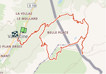

Length
16.3 km

Max alt
2313 m

Uphill gradient
1196 m
Km-Effort
32 km

Min alt
1259 m

Downhill gradient
1187 m
Boucle
Yes
Creation date :
2022-08-07 06:14:24.906
Updated on :
2022-08-21 06:04:51.144
6h40
Difficulty : Medium

FREE GPS app for hiking
 SityTrail
IGN / Geographical institutes
SityTrail Plus
The world is yours!
About
Trail Walking of 16.3 km to be discovered at Auvergne-Rhône-Alpes, Upper Savoy, Vallorcine. This trail is proposed by aris.
Positioning
Country:
France
Region :
Auvergne-Rhône-Alpes
Department/Province :
Upper Savoy
Municipality :
Vallorcine
Location:
Unknown
Start:(Dec)
Start:(UTM)
340095 ; 5099876 (32T) N.
Comments