


GTJ jour1

werth
User
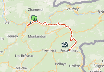

Length
18.6 km

Max alt
917 m

Uphill gradient
850 m
Km-Effort
28 km

Min alt
383 m

Downhill gradient
374 m
Boucle
No
Creation date :
2022-08-04 04:51:15.276
Updated on :
2022-08-07 16:45:42.176
7h38
Difficulty : Difficult

FREE GPS app for hiking
 SityTrail
IGN / Geographical institutes
SityTrail Plus
The world is yours!
About
Trail Walking of 18.6 km to be discovered at Bourgogne-Franche-Comté, Doubs, Saint-Hippolyte. This trail is proposed by werth.
Photos


Positioning
Country:
France
Region :
Bourgogne-Franche-Comté
Department/Province :
Doubs
Municipality :
Saint-Hippolyte
Location:
Unknown
Start:(Dec)
Start:(UTM)
335454 ; 5243336 (32T) N.
Comments