


Activity

thonyc
User GUIDE
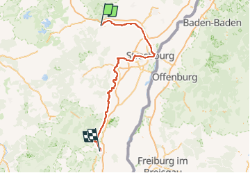

Length
148 km

Max alt
277 m

Uphill gradient
1233 m
Km-Effort
165 km

Min alt
126 m

Downhill gradient
1231 m
Boucle
No
Creation date :
2022-08-08 10:03:07.274
Updated on :
2022-08-08 10:08:44.106
0m
Difficulty : Very easy

FREE GPS app for hiking
 SityTrail
IGN / Geographical institutes
SityTrail Plus
The world is yours!
About
Trail Bicycle tourism of 148 km to be discovered at Grand Est, Bas-Rhin, Saverne. This trail is proposed by thonyc.
Description
Canal Marne-Rhin.
Starasbourg.
Canal de La Bruche.
Route des vins.
Colmar.
Positioning
Country:
France
Region :
Grand Est
Department/Province :
Bas-Rhin
Municipality :
Saverne
Location:
Unknown
Start:(Dec)
Start:(UTM)
379626 ; 5400072 (32U) N.
Comments