


Ecouge

raygautier
User
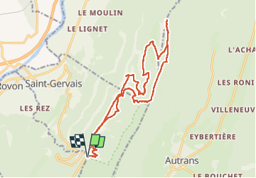

Length
21 km

Max alt
1616 m

Uphill gradient
949 m
Km-Effort
34 km

Min alt
898 m

Downhill gradient
946 m
Boucle
Yes
Creation date :
2022-08-09 07:17:51.0
Updated on :
2022-08-09 17:55:29.462
5h22
Difficulty : Very difficult

FREE GPS app for hiking
 SityTrail
IGN / Geographical institutes
SityTrail Plus
The world is yours!
About
Trail Walking of 21 km to be discovered at Auvergne-Rhône-Alpes, Isère, Saint-Gervais. This trail is proposed by raygautier.
Positioning
Country:
France
Region :
Auvergne-Rhône-Alpes
Department/Province :
Isère
Municipality :
Saint-Gervais
Location:
Unknown
Start:(Dec)
Start:(UTM)
696311 ; 5005663 (31T) N.
Comments