


azillanet olonzac

CANON2
User
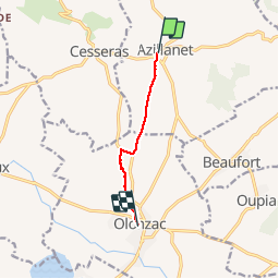

Length
5.8 km

Max alt
93 m

Uphill gradient
26 m
Km-Effort
6.3 km

Min alt
47 m

Downhill gradient
64 m
Boucle
No
Creation date :
2019-05-15 13:09:02.195
Updated on :
2019-05-15 13:09:02.753
1h22
Difficulty : Unknown

FREE GPS app for hiking
 SityTrail
IGN / Geographical institutes
SityTrail Plus
The world is yours!
About
Trail Walking of 5.8 km to be discovered at Occitania, Hérault, Azillanet. This trail is proposed by CANON2.
Positioning
Country:
France
Region :
Occitania
Department/Province :
Hérault
Municipality :
Azillanet
Location:
Unknown
Start:(Dec)
Start:(UTM)
478556 ; 4796801 (31T) N.
Comments