RUMEGIES TTES LES CHAPELLES

dehemjacques
User
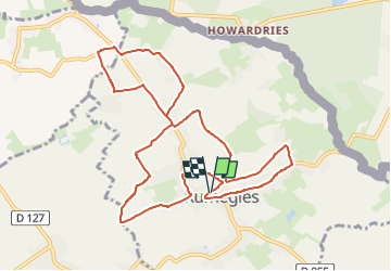

Length
10 km

Max alt
31 m

Uphill gradient
34 m
Km-Effort
10.4 km

Min alt
19 m

Downhill gradient
35 m
Boucle
Yes
Creation date :
2022-08-10 16:55:32.281
Updated on :
2022-08-10 16:55:36.86
2h22
Difficulty : Medium

FREE GPS app for hiking
 SityTrail
IGN / Geographical institutes
SityTrail Plus
The world is yours!
About
Trail Walking of 10 km to be discovered at Hauts-de-France, Nord, Rumegies. This trail is proposed by dehemjacques.
Positioning
Country:
France
Region :
Hauts-de-France
Department/Province :
Nord
Municipality :
Rumegies
Location:
Unknown
Start:(Dec)
Start:(UTM)
524817 ; 5593114 (31U) N.
Comments