


2022-08-12_09h23m03_2022-08-12_883146252_GPX Download_ Rapide de pradons – l'Ardèche à Ruoms Circuit à partir de Ruoms

Linerou
User
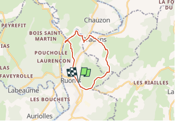

Length
10.6 km

Max alt
257 m

Uphill gradient
301 m
Km-Effort
14.7 km

Min alt
111 m

Downhill gradient
301 m
Boucle
Yes
Creation date :
2022-08-12 07:23:03.516
Updated on :
2022-08-12 07:23:04.987

FREE GPS app for hiking
 SityTrail
IGN / Geographical institutes
SityTrail Plus
The world is yours!
About
Trail of 10.6 km to be discovered at Auvergne-Rhône-Alpes, Ardèche, Ruoms. This trail is proposed by Linerou.
Positioning
Country:
France
Region :
Auvergne-Rhône-Alpes
Department/Province :
Ardèche
Municipality :
Ruoms
Location:
Unknown
Start:(Dec)
Start:(UTM)
607106 ; 4923003 (31T) N.
Comments