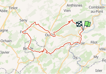
Trail Cycle Hamoir - Ouffet - Photo
 kodak
kodak

User

© OpenStreetMap contributors
Length
Length
34 km
Max alt
Max alt
304 m
Uphill gradient
Uphill gradient
489 m
Km-Effort
Km-Effort  
41 km
Min alt
Min alt
105 m
Downhill gradient
Downhill gradient
487 m
Boucle
Boucle
Yes
Creation date :
2022-08-12 11:58:59.524
Updated on :
2022-08-12 12:00:31.985

(0 Reviews)

Cycle
Cycle
0m
Difficulty : Easy

Scan this QR Code to open this trail in the SityTrail application

FREE GPS app for hiking

Logo SityTrail SityTrail

IGN / Geographical institutes

Download SityTrail from the App Store Download SityTrail from Google Play

Logo SityTrail SityTrail Plus

The world is yours!

Download SityTrail from the App Store Download SityTrail from Google Play Download SityTrail on Huawei AppGallery

About

Trail Cycle of 34 km to be discovered at Wallonia, Liège, Hamoir. This trail is proposed by kodak.

Elevation profile

Points of interest

Point of interest Hamoir - 31 +32 - Photo
kodak
HAMOIR 
Point of interest Hamoir - 32 +33 - Photo
kodak
HAMOIR 
Point of interest Hamoir - 33 +68 - Photo
kodak
HAMOIR 
Point of interest Durbuy - 68 +71 - Photo
kodak
DURBUY 
Point of interest Durbuy - 71 +73 - Photo
kodak
DURBUY 
Point of interest Clavier - 73 +75 - Photo
kodak
CLAVIER 
Point of interest Ouffet - 75 +76 - Photo
kodak
OUFFET 
Point of interest Ouffet - 76 +70 - Photo
kodak
OUFFET 
Point of interest Ouffet - 70 +69 - Photo
kodak
OUFFET 
Point of interest Hamoir - 69 +31 - Photo
kodak
HAMOIR 

Positioning

Country:
Belgium
Region :
Wallonia
Department/Province :
Liège
Municipality :
Hamoir
Location:
Unknown
Start:(UTM)
680561 ; 5591069 (31U) N.


Close
My subscriptions